Wednesday, March 27, 2019

North Eastern Victorian Silos

After leaving Port Fairy we headed north east towards Ballarat. Our next evening was spent camped at the Newstead racecourse and recreation ground 17 km south-west of Castlemaine. Its also listed in Wiki Camps and your $10 fee per night gets you showers, toilets, fresh water and a dump point.

Our next days travel continued on through Bendigo and towards the Strathbogie Ranges. We were here to spend the evening with our friends on their property at Strathbogie. A lovely meal including many bottles of red wine saw us eventually head of to bed quite late.

From here we continued through Euroa before joining the Hume Freeway onto Benalla and to our campsite for the next two evenings.

We are spending two days camped at Broken Creek bush camp 16 km north-west of Benalla. Fees are just $7.50 per person and this includes showers, toilets, freshwater and a dump point. This site is listed in Wiki Camps.

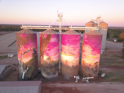
Four towns in northeastern Victoria have now painted their silos, to form their own silo art trail.

Tungamah, Devenish St James and Goorambat are all less than 50 kilometres apart.


Our campsite is in close proximity to these four towns so a day trip was the order of the day in photographing these silos.

We were surprised that all these silos were behind fences with no way of getting up close and personal like we could with the silos in the Wimmera.

We started the trail in Tungamah as it was the furthermost town from where we were staying. 

Then it was south towards St James where one of the silos was still in the process of being painted.

Our favourite silos were in Devenish, depicting two servicewomen 100 years apart.

Apart from the silos in Goorambat, the local Uniting Church has a mural on its interior wall painted by street artist Adnate who also painted the beautiful silos at Sheep Hills.

We followed up with a lovely lunch in Benalla and photos of some local street art.

 Before leaving Victoria there was just one more silo to be photographed. This was in the town of Rochester just south of Echuca.

Thursday, March 21, 2019

Towards the Grampians National Park

While we were photographing the Rupanyup silo a man also taking photos mentioned about an interesting side trip to the small rural town of Murtoa.

It involved a 15 km detour from our intended route but we are so glad that we did. 

The Murtoa 'Stick Shed' is a national heritage-listed icon. We arrived just at 10 am and joined the tour with over a dozen other people. 

The 'Stick Shed' was a grain store constructed in 1941 as a solution for grain storage during World War ll wheat glut when exports were restricted.

The shed is constructed from 560 unmilled poles or 'sticks' (56 rows of 10) to support the corrugated iron roof with a concrete floor.

The shed measures 270 metres long by 60 metres wide and 20 metres high.

From here we took a minor road towards Stawell before heading south-west towards Pomonal. We spent the next two evenings camped at the old man emu stay 7 km from Halls Gap.

On our first day, we drove to Mackenzie Falls in the Grampians National Park and then climbed down to the base of the falls to take some photos. My phone app measured the climb back to the car park as the equivalent to climbing 23 floors.  

From here we drove onto Reed Lookout and the Balconies.

It was just a short drive to Boroka Lookout with views down the valley towards Halls Gap and Lake Bellfield in the distance.

A well-deserved lunch at one of the local cafes after our morning's exercise...

On the following morning, it was an early start to drive to the car park before tackling the Pinnacles walk.  Distance is 5.5 km return with an elevation change of 280 metres and the track is graded medium to hard. It took us a solid hour to make the summit including stops for rest and photo opportunities.

Even though it took as forty minutes to return to the car park we considered the trip down harder on our legs. The phone app measured the climb to the Pinnacles to be equivalent to climbing 70 floors and it certainly felt like that to us. 

Tuesday, March 19, 2019

Tracking Australian Silo Art - Victoria

Last September we spent the evening camped at Thallon in Queensland. We were there so that we could photograph the towns beautifully painted silos.

In 2015, the first silo ever painted in Australia was in the small town of Brim located in the Wimmera-Mallee region of western Victoria.

Following on from the success generated by this, five other silos in the same region have now been painted, creating the first silo art trail which covers 200 kilometres, and links the neighbouring towns of Lascelles, Patchewollock, Brim and Rupanyup. There are two other silos that are located at Rosebery and Sheep Hills.

Future art trails are now being planned which will turn these large drab silos into wonderful works of art.

Many smaller towns have now seen the economic benefit generated by having silos painted. Instead of driving through these towns, people are now spending time viewing them which in turn leads towards accommodation, food and fuel.

GrainCorp who own most of the silos has made more available to be painted throughout regional Australia. Very few of these now store grain, instead, it's now stored on the ground covered with large blue tarpaulins.

Before tackling the silo art trail we made our way south from Cobar to camp just outside Balranald. We camped overnight in the Yanga National Park beside the Murrumbidgee River. 

From here we crossed over into Victoria at Tooleybuc, before passing through Ouyen and taking a minor road through to Patchewollock. Its the most northern painted silo. From here we will continue to head south over the next two days photographing each silo.

 A local sheep and wheat farmer 'Noodle Hulland' from the district is depicted on this silo. Painted by Fintan Magee a Brisbane based street artist this silo was completed in October 2016.

With the next silo located in Lascelles just 59 km away, we thought we would continue onto here and spend the evening. When we arrived the local RV stop wasn't very inviting as it was located on the highway so we took our photos and continued on. 
Painted by Melbourne street artist Rone these silos depict the faces of local couple Geoff and Merrilyn Horman. They were painted in June 2017.

A possible campsite on Wiki Camps looked inviting. It was located on the banks of Lake Lascelles at Hopetoun. Its a gold coin donation to stay here and is quite popular.

Knowing that the silos at Rosebery and Brim faced west, we left just before lunch so at least we wouldn't be looking into the sun while taking our photos.

The Rosebery silo was painted by artist Kaff-eine. She assisted Rone who painted the Lascelles silo. This silo was completed in October 2017.

The Brim silos were the first to be completed in 2015 by Guido van Helten. This inspired other artists to paint the other five silos that make up this trail.

We were really taken with the silos at Sheep Hills. Painted by Adnate, a street artist famous for his work with aboriginal communities. The detail and colour were just unbelievable especially as we took the photos just after sunrise during the golden hour. The silos here are away from the main highway and there are just a few houses nearby and an old pub that has since closed its doors. This mural was completed in December 2016.

We ended the silo trail in Rupanyup. Here the silo was painted by Russian artist Julia Volchkova and completed in April 2017. She mainly focuses on portraits.

Sunday, March 10, 2019

North-West New South Wales

At Armidale, we joined the New England Highway as we headed south towards Tamworth.

Leaving Tamworth, we joined the Oxley Highway as we steered ourselves west. Our campsite tonight is just off the highway 12 km east of Gunnedah. It's known as the Redbank camping area and is beside the Namoi River. Its quite a large area with flushing toilets. 

We backed in as far as we could to try and lessen the amount of truck noise during the evening but Ros unlike me is a light sleeper, so she was awake on and off during the night.
Once we had both had several hot coffees and breakfast out of the way we left just on 08:30. 
Passing through Gunnedah just 10 minutes later had us now on our way to  Coonabarabran. There are currently severe water restrictions here with showers limited to 2 minutes and no watering of gardens, so you just imagine how everything looks. 

We wanted to photograph the water tower in the small town of Gulargambone with the most direct route taking us out through the Warrunbungle National Park. The load limit on the bridge just past the national park boundary is much lighter than our rig so we took a detour via Gilgandra to get our photo.

Where possible we prefer to take minor roads rather than highways so cross country we went for the next 86 km until we reached Warren.  Here we joined the Mitchell Highway at Nevertire before reaching Nyngan.

It was so sad to see the result of the drought on the country we have been passing through. The irrigation channels around Warren were bone dry and where there are normally crops growing in the fields, now there is nothing. The strong winds we have been experiencing for the past two days are just blowing what topsoil there is away. 

It was still quite early so we pushed north towards Bourke. We found a spot to camp 44 km north in the small town of Girilambone. It's in Wiki camps and a gold coin donation is requested for stopping in the local CWA park. They have one flushing toilet and shower.

Even though we didn't use these facilities we were more than happy to leave $5.00 at the pub to help with the upkeep. Over a few beers, the publican told us that the town was nearly out of water. Unfortunately, the towns bore water has far too much salinity and the council will now be arranging to install tanks at each house and have water trucked in. Of course, there will be a daily limit on usage.

The camping area as you can imagine after many years of drought has the occasional tuft of dead grass. The whole area was covered in prickles so thongs just weren't the go.

In the morning we shared the area with some kangaroos. I'm not sure how they are surviving.

We encountered a B Double on one of the minor roads and I was forced to move over and hit a large hole on the side of the road. Our chine bar on our vans near side has cracked.

We had planned to continue onto Bourke and do the top part of the Darling River Run as far as Wilcannia. But after seeing the result of the drought and needing to have our chine bar welded we retraced our route back to Nyngan and continued west towards Cobar. We are holed up in the caravan park with the temperature outside currently at 40 degrees and climbing. Our vans aircon is now down to 28 degrees and dropping.