Wednesday, September 27, 2017

Warroora Station

We left our campsite in Cape Range National Park at 7:15 for the drive into Exmouth. Half an hour after arriving and having filled our water tanks and emptied our toilet cassette, we were on our way south. The information centre in Exmouth has two freshwater taps located in its car park, with easy access for vans. The dump point is nearby, near the oval, also with easy access for vans.
 
Our first stop was Coral Bay, where we considered staying if we could find a suitable site at one of the two caravan parks. However, once we saw how crowded the vans were, we soon changed our minds. It was just way too busy for us.
 
We drove 15 km south of Coral Bay, then left the highway and turned towards the coast. We had heard that the corrugations and rocky outcrops on the 13 km access road were bad, so we stopped briefly to reduce our tyre pressures to better handle what lay ahead.
 
We were heading to camp at Warroora Station, which is pronounced Warra. The station runs along a 50 km frontage of the Ningaloo Reef.
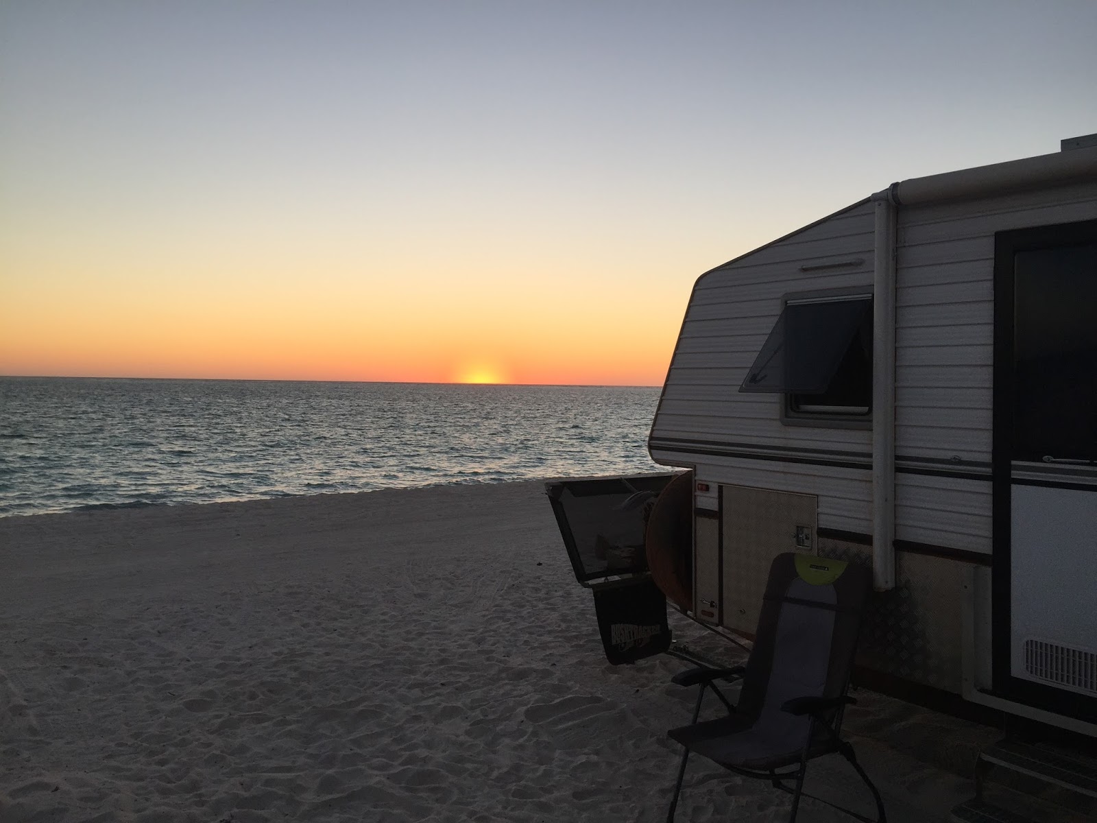
Our campsite at the 14-mile was right on the beach, with a large sand dune behind us and the most fantastic view of the waves breaking on the reef in front.


Talk about a piece of paradise. 


Camping fees are $10 per adult per day or $50 per week, with no charge for children under 18. Bookings are not accepted, but the station is listed on WikiCamps, and you can contact the caretakers for information. Chemical toilets are required; if you don't have one, you can hire one from the caretaker.

Just before arriving at the caretakers' van, I saw a sign requesting that tyre pressures be dropped between 20 and 25 psi to handle the beach access, so I lowered ours to 24 psi. It was just as well because each site consisted of very soft sand. There is a dump point and a rubbish tip, as well as phone and internet coverage, on a hill above the rubbish tip. During our stay, I discovered a water pump located behind the dunes.

Our lagoon behind the reef was a fantastic spot to swim, where we saw turtles, and on our last day, a reef shark cruised by just a metre away in the water.
We regularly watched whales breaching outside the reef, and Craig, our next-door neighbour, caught squid from his boat, which were absolutely delicious when cooked with panko breadcrumbs.

It's a very popular spot, with 26 vans camped along our section of the beach north of the caretaker's caravan, and even more camping to the south and on a headland. The sites are spacious, and you don't feel hemmed in like you would in a caravan park.


If you haven't experienced camping on the beach in this part of the world, make sure you are prepared for the wind. The wind is always a constant factor; only its strength varies. Where you would typically expect the wind to die down at night, it continues to blow.
 
On one of our Saturday mornings, we ventured into Coral Bay to shop and have lunch at Bill's Tavern.


We enjoyed the laid-back lifestyle at the station, so whenever we return to WA, we plan to make staying here a priority.

Friday, September 8, 2017

Millstream Chichester National Park

We left Wittenoom just after 8am, following a very sleepless night, and were now heading to Millstream Chichester National Park. 
 
The van was constantly buffeted by strong winds rushing down through the gorge. We could have driven along part of the road we took yesterday, but we chose a different route that passed Mulga Park and Mt. Florence stations. We travelled beside the Tom Price railway for 28 km before turning onto the Pannawonica road for 18 km to reach the entrance of the national park. This section of road and the 5 km into our campsite at Stargazers campground were quite ordinary, featuring corrugations and rocky patches.


We chose this campground because it was generator-free, but later in the day, we drove to the Miliyanha campground, which we found had a much nicer lookout and newer facilities.


For the life of us, we cannot understand why national parks would provide better facilities so that people could run their generators. As a result, our planned four-day stay was reduced to just two days.


It was also interesting to discover that the towns of Karratha, Roebourne, and Dampier receive their water supply from this national park. 


Deep Reach Pool is located along the Fortescue River, which runs through the park. It's extensive and also very deep, making it ideal for swimming, provided you have some form of flotation device, such as a noodle. I was surprised to find that fishing was permitted, and the area adjacent to the waterhole was surrounded by gas BBQS, shade, and toilets.


We visited the Millstream Homestead, built in 1920. 

The lease on the pastoral property was established in the 1800s; at one stage, over 20,000 sheep were grazed there. A walking trail departs from the homestead and winds through groves of date palms and large paperbark trees. The entire area is adorned with clear, flowing streams and wetlands filled with water lilies. 


Our camp host, Burnie, recommended we visit Python Pool. Our original plan was to stop there on our way out of the park tomorrow. However, it was 19 km off the main road with nowhere to park the van, so his advice was very helpful.
 
The total trip was 116 km. The drive was stunning, with the sun positioned just right and the hills covered in spinifex, and some speckled clouds added a picturesque touch to our photos.


Of course, the waterfall into the pool at the base of the cliffs was not flowing this late in the dry season. However, we could only imagine how wonderful it must be to see it like this.


On our way back, we were fortunate enough to see one of the ore trains returning to Tom Price.

Wednesday, September 6, 2017

Wittenoom Gorge

Our plan for this evening, after leaving Hamersley Gorge, was to camp at Wittenoom Gorge. We drove past the now-abandoned township and into the gorge, which was marked by asbestos warning signs. 


Asbestos found in the creek bed near our camp.

We were searching for a site with water views, but several of the options we considered would have been too difficult to manoeuvre the van into without risking damage. As it was starting to get late in the day, we drove back towards the old township, where we found access down into a creek bed that allowed me to turn around.


I was able to capture some lovely photos and videos with the drone as the sunset painted the cliffs that surrounded us.


Tuesday, September 5, 2017

Karijini National Park

Our campsite at the Mt Robinson rest area before entering Karijini National Park.


We arrived just after 8:00 a.m. and paid our park entry fee of $6.00, which is half price because we have an NSW Seniors Card. And we were confronted with this sign wherever we went...

Then we headed to the camp host to pay our camping fees of $14.00 per day for both of us.
 
We were allocated site 34 on the Bungarra Loop in the non-generator area at Dales Gorge campground, and we should have given more thought to staying on this site because the van on the following site had bunk beds. It could only mean ankle biters.


All the attractions in Karijini are very accessible. It's just a matter of driving to a car park with most gorge access points or lookouts, which are typically 50 to 300 metres away. All the trails are colour-coded, ranging from beginner to very adventurous.
 
Circular and Fern Pool were very close to our camp, so we wandered off to the car park and then down into Dales Gorge. As we were descending, I overheard a woman saying that there were a total of 286 steps to climb to return to the car park. Both pools were very enjoyable, with Fern Pool being the coldest.


We spent the rest of the afternoon sitting in the shade of the van, trying to hide from the near gale-force winds that were whipping up red dust in all directions. Most of the trees here have been burnt and look like they will never recover, while only a handful surrounding us have started to grow leaves. Unfortunately, the conditions remained the same throughout our entire stay.
 
The couple from the van with the bunks returned with a small child in tow, and we were then forced to listen to cartoons played loudly for the rest of the afternoon. Around 6 pm, they started up a generator so they could use their microwave for cooking. Unfortunately, the camp hosts had retired for the evening, so I asked them to turn off the generator, but they refused and continued until they finished.
 
As we left the next morning to explore some of the other gorges, I stopped to complain about the couple using the generator. As we continued, we could hear on the UHF radio that a ranger was being called to visit them and advise that this area was designated as a generator-free zone. We remained generator-free for the rest of our evenings.
 
The Banjima Drive North Road begins at the Visitors Centre and extends for 43 km to the gorges in the north-west of the park. This road is very corrugated and rocky along its entire length, just like all the access roads to the other gorges. We stopped after 100 metres, where I reduced the 4wd tyres to 30 psi, before stopping shortly after and dropping them further to 26 psi to cope with the worsening road conditions.


We passed many vehicles that were driving along at a snail's pace, with what I can only assume were bitumen tyre pressures. In total, for the day, we covered 113 km. We decided to drive to the furthest gorge and then work our way back. At Weano Gorge, we walked down into the floor of the gorge and followed it for several hundred metres before reaching some quite deep seasonal pools and very large slippery boulders, so we decided not to go any further.


Unfortunately, we are no longer as agile as rock wallabies, so we are limited in what we can actually see.


At Oxer Lookout in the Weano area, you are treated to the most amazing views over the junction of Weano, Red, Hancock, and Joffre Gorges.

Joffre Gorge, in particular, was very spectacular. Unfortunately, the falls were not flowing, but they would cascade several hundred metres down into the gorge.

We watched a couple start to climb out, and we were both thankful it wasn't us; mind you, they were probably about forty years younger than we were.


Kalamina Falls was 6km along a very rough and rocky road. We walked down to take some photos, but the actual swimming hole looked stagnant and not very welcoming.


We drove into Tom Price on the bitumen road, where we refuelled and filled all our water tanks at a free water outlet opposite the swimming pool.
 
We were now on our way to Hamersley Gorge along what I can only describe as a very good dirt road, with just a few minor corrugations and quite a few bulldust holes. This gorge is one of the most spectacular in the park, featuring a diverse array of rock formations and a lovely swimming hole.