We spent several days camping here before heading on to Morven, which is only 89 kilometres further west of Mitchell. We stayed at the Morven recreation ground, where a gold coin donation for using the facilities is appreciated.

We arrived in Longreach and checked into the caravan park after deciding that the free camp outside town on the Thompson River was not suitable for us. We spent many hours viewing the Stockman's Hall of Fame and the Qantas Museum. Hugh Sawrey, along with R.M. Williams, played a key role in establishing the Hall of Fame. We own a couple of Sawrey originals and were a little disappointed that so little of his work was on display.
This is a self-portrait of Hugh Sawrey.
Leaving Longreach, we headed to Winton, where we spent about five hours exploring the Matilda Centre, which we found very interesting. Our camp for the night was Long Waterhole, about five kilometres south of Winton.

And just after sunrise:
We set off early the next morning for the 110 kilometre journey to Lark Quarry Conservation Park. It is currently the only recorded dinosaur stampede on Earth. In this location, around 95 million years ago, a large herd of small bipedal dinosaurs gathered at the edge of a forest lake to drink. The herd was stalked by a large Theropod – a four-tonne, sharp-clawed, meat-eating dinosaur. The herd panic-stricken, stampeded across the muddy flats to escape the Theropod’s hungry jaws. A record of those terrifying few minutes is preserved in over 3300 fossilised footprints. The footprints reveal a cooler, wetter world, when dinosaurs roamed the Earth and the era of mammals was yet to come. The fossils had been perfectly preserved underground for 95 million years, but exposure to the sun, rain, people, and wildlife was beginning to cause damage. To prevent further deterioration of the Trackways, the building was designed to:
- Stabilise temperature and humidity fluctuations
- Stop water from running over the tracks
- Keep humans and animals off the fragile Trackways
After the tour, we continued south towards Jundah. We had planned to camp on the banks of the Mayne River, but due to recent rains, the river was now in flood.
We continued hoping to camp on the Thompson River outside Jundah, but once again the whole area was flooded, so we stayed at the Jundah caravan park, which we had all to ourselves.
Spoke with the locals the next morning to find out that Cooper Creek at Windorah and the Barcoo River were also flooded. That left us no alternative but to drive back to Longreach on the bitumen.
The following day, we drove to Emerald and camped at Lake Maraboon, then proceeded to the Injune Caravan Park, where we spent the night and replenished our water supplies before heading off to Mount Moffatt. We met the ranger on the way in, who advised that there were many washouts caused by the recent rains and to take our time. Mount Moffatt is 160 kilometres north-west of Injune.
We camped at Dragonelly Rockhole, the same campground that Steve Gibbs and his group stayed at when they produced their first Bushtracker Lifestyle DVD. There are three other camping areas within the park, and the one suitable for vans would be West Branch.
We spent three nights camping at Dragonelly and had the entire camp to ourselves during our stay. In fact, only two other groups were camping in the park during our stay. The park averages about 2000 visitors per year.
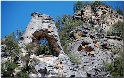
You can take a circuit drive around the park, then stop and follow walking tracks that lead to unusual sites with many different types of rock formations.
Some of the formations include Cathedral Rock.
You can take a circuit drive around the park, then stop and follow walking tracks that lead to unusual sites with many different types of rock formations.
Some of the formations include Cathedral Rock.
The Chimneys:
The looking glass:
Lot's wife:
Marlong Arch:
Top Shelter Shed, known as the roof of Queensland:
And our last night's campfire in the trusty "Pig" before leaving Mt Moffatt.
We decided to spend the following night at the Kapunda Fishing Club just north of St George, which is situated on the Balonne River. Yet another evening where we had the place to ourselves.
Our next day's travelling saw us heading to Lightning Ridge, passing through Dirranbandi and Hebel, before camping at a roadside rest area about 5 kilometres south of the Ridge.
We had never stayed at Yarrie Lake, which is situated about 25 kilometres south-west of Narrabri. They have powered sites, but we chose to drive round to the other side of the lake where we had the place to ourselves.
We visited the Australia Telescope on our way into Narrabri, then travelled through the northern part of Mt Kaputar National Park towards Bingara, where we often camp on the Gwydir River just outside town.
We spent several lovely nights camping by the river before the short drive home to Sawtell. Ros cooked one of our favourite dishes, chicken and almonds with chilli and lime juice.


