Tuesday, September 26, 2023

Bound for the Coast

 From Julia Creek, we continued east along the Flinders Highway towards Richmond on what we can only describe as the worst road we've ever travelled, with damage on the left-hand side caused by the large B-double and triple trucks that use these roads. 

We stayed on the centre line whenever possible, provided we could see far enough ahead to avoid furrows created on these roads, which were never built to handle the weights of such trucks and their loads. These road conditions persisted for a further 114 kilometres until we reached Hughenden, where we camped at the free RV park — a large dirt car park the size of two football fields, with a dump point and town water. 

We had planned to spend two nights here, but one night was enough after walking around town and dealing with the swirling wind kicking up dust in the RV park.


The road condition heading east towards Charters Towers began to improve, making the 246-kilometre drive much more enjoyable. We stopped briefly here to refuel before continuing another twenty kilometres east to camp at a free site beside the Burdekin River at Macrossan Park, where toilets and rubbish bins are available. 

Again, the area was dirt, but we positioned ourselves near a large patch of grass, even though it was dry, which would help prevent us from being covered in dirt from wind and passing traffic. It was busy, likely due to the on-site toilets, and many of the permanent campsites appeared to have been in use for quite some time.


The old sandstone pylons have been replaced because the weight of trains carrying refined metals and mineral concentrate to the coast would be unable to support the additional loads.


The rest of our trip along the Flinders Highway was a pleasant drive as we headed towards the Bruce Highway. About thirty kilometres west of Townsville, at Woodstock, we turned onto a minor road that took us past properties with mango plantations. This saved us from having to travel an extra sixty kilometres.

Since leaving home in early June, the traffic has been light in the areas we've travelled through, so it was quite a shock to arrive at the Bruce Highway and be greeted by streams of traffic in both directions. The highway remained busy for the next one hundred and fifty-three kilometres until we reached Bowen. 

All the van parks were fully booked, even though the school holidays were nearly over, so we spent the next four nights at a farm stay twenty kilometres south-west of Bowen at Glen Erin Farmstay, costing twenty dollars a night, where bore water was available, along with a dump point, showers, and toilets.


We travelled to Airlie Beach and checked into a caravan park on Shute Harbour Road. It's been eight years since our last visit, and we were amazed by the growth here. New marinas and resorts have appeared, and the Airlie Beach Hotel has been transformed into a large accommodation complex. While here, we visited Proserpine to pre-poll for the voice referendum.

                                                                    
Airlie Beach and North Queensland have been our annual escapes from winter in Canberra, where we lived for over forty years, so we have seen many changes over time. We are booked into Bushtracker on Wednesday, the eighth of November, for a van service that will include replacing the wheel bearings.
 
We are currently organising timings and accommodation for the upcoming month, as it is about 1,000 kilometres from Airlie Beach to the factory at Kunda Park on the Sunshine Coast. After leaving Airlie Beach, it was just over fifty kilometres to our next four-night stop at Lake Proserpine. The only facilities here are a small kiosk selling essentials, showers, toilets, and rubbish bins. The campsite overlooks the lake, and the nightly charge is $10 per person.
 
Unfortunately, during our four days here, we experienced strong, gusty winds, and as often happens on our departure day, the winds have now eased.

Thursday, September 21, 2023

Towards Julia Creek

After three days in Boulia, we headed north towards Mt Isa along the Diamantina Development Road, which had occasional passing lanes; otherwise, it was a single-lane bitumen road. Remarkably, we are in the twenty-first century, yet we still have single-lane bitumen roads. 

On the way, we passed through Dajarra, a small town that appears to be on its last legs. Thank goodness for having air conditioning in the vehicle, with the outside temperature showing 46 degrees.


We filled up at the ISA, then parked on a side street, and both enjoyed our enormous salad sandwiches at the Buffs Club, where we had eaten before. They were so large that we could have shared just one between us. Afterwards, we headed to the attached bottle shop where Ros could buy her favourite Stone and Wood Pacific Ale, red wine, and a nice bottle of Whitney Neill gin. 

We then headed west to camp at Mary Kathleen, just as we had done for my birthday on August 11. However, fewer people are camping here because we are late in the season, and the daily temperatures are hovering around forty degrees. We are surrounded by the cement pads that used to be for the carports. 


As we were not in a rush and it was Queensland school holidays, we decided to spend three days here before heading to Julia Creek. We had never stayed at the RV stop on the eastern outskirts of town. Still, upon arriving, we couldn't believe how small the waterhole actually was and wondered why anyone would want to stay here for the allocated four days, apart from it being free. 

We had planned to stay for four days, but just two proved to be enough for us. There are many geese here that everyone feeds, so having food or a drink outside the van becomes quite tricky without them approaching.

Friday, September 15, 2023

Plenty and Donohue Highways

After leaving Rainbow Valley, we headed north towards Alice Springs, making a quick stop to refuel and fill two jerry cans. Then, we continued another sixty-eight kilometres north along the Stuart Highway before turning east onto the Plenty Highway. Just over sixty kilometres later, we passed Gemtree, which has a caravan park and a gem fossicking area.

This is our fourth trip across the Plenty and Donohue routes, and although there are large sections of dirt, it remains a quicker way to travel into Queensland than taking the bitumen north across the Barkly Tableland.


It's probably four years since we last crossed this way, and we were surprised to see that the single-lane bitumen has now been extended as far as the Aboriginal community at Harts Range, about one hundred and seventy kilometres from the Stuart Highway.


We spent a very peaceful night camped on the outskirts of the Aboriginal community of Atitjere (Harts Range), where overnight stays are permitted. The facilities include a sheltered picnic table and rubbish bins.


Our second day's journey took us further east towards the NT/QLD border, with the bitumen extending another twenty kilometres before it faded out, forcing us to stop and lower our tyre pressures for what lay ahead. It was a further 216 kilometres until we reached Jervois Station, as the road conditions included corrugations and rocky outcrops of varying difficulty for much of this stretch.


We refuelled at Jervois Station for $3.00 per litre before travelling another sixty kilometres to camp for the night on the banks of Arthur Creek, where two other groups had stopped. However, they continued on after a lunch break, so we had the place to ourselves. It was hot at thirty-seven degrees, and the flies were extremely persistent. 

I was up at 6:30, checking tyre pressures on our Chev and van before the sun rose, and we were back on the road just after 7:30 am. We passed near Tobermorey Station, just shy of the Queensland border, and gained half an hour due to the different time zones. We didn't stop there for fuel as our two jerry cans were still full, and I emptied them into the Chev when we stopped later that day. 

That evening, we camped on the banks of the Georgina River, one hundred and twenty kilometres east of Tobermorey Station. We were the only ones there for the night, although several campers were heading in both directions, but not stopping to stay. We had planned to cook our dinner over our fire pit, but with the wind and the super dry grass surrounding our campsite, we opted to cook on our gas stove.


Another early morning, pumping up tyres for the remaining one hundred and eighteen-kilometre sealed journey into Bouila, avoiding the dirt and dust of the past two days. We checked into Bouila Caravan Park, which charged a nightly fee of $20 for power and water. It was a wonderful feeling to have green grass underfoot after five days of dirt and dust. With unlimited water, Ros managed to finish seven loads of laundry in our van's four-kilogram washing machine.

Wednesday, September 13, 2023

Rainbow Valley

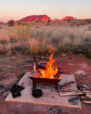
It took us almost twenty years to return to Rainbow Valley. This time, we brought our drone, which provided a fantastic perspective on our previous visit. Rainbow Valley is situated in the James Range, seventy-four kilometres south-east of Alice Springs. 

Access is via a twenty-two-kilometre sandy and corrugated track east of the Stuart Highway. Our van tyres were deflated to 28 psi, and our Chevrolet tyres were lowered from 65 to 40 psi to ensure a smoother ride. 


It's common to see camels in desert areas, but we were surprised to encounter them so close to the road. 

There are two campgrounds, and we are at the bush campsite, which has ten bays, more suitable for caravans. The main camp is closer to the claypan and sandstone cliffs, but the five sites there are much smaller and better suited for camper trailers and tents.


On our first evening, we cooked a marinated beef brisket that we brought from home. First, it was cooked in the camp oven with heat beads, then finished over the fire and served with a Thai-style salad and crispy onion.


Fly nets are essential, and the pesky little bugs only disappear after sunset, so eating our dinner under the stars in front of the fire was lovely.


While the cliffs behind the claypan are impressive during the day, they truly reveal their beauty once the sun sets. This is when the colours of the sandstone genuinely come alive.

Monday, September 4, 2023

The West MacDonnell Ranges

We were heading out to spend the next five days camping at the Finke River, one hundred and thirty kilometres west of Alice Springs. The Finke two-mile campsite has no facilities, and you can camp close to the river on river rocks or further back under tall ghost gum trees.


It is also a popular destination for groups of much younger hikers than us, who are completing sections of the two-hundred-and-thirty-kilometre Larapinta Trail. While we've been here, there have been three to four-wheel-drive vehicles based at the site, towing trailers to support the walkers with food and their accommodation in tents and swags.


Each afternoon, when the walkers return to base, they head down to the river to cool off, wash away the day's grime and sweat, before being fed and then retiring early for the next day's walk. There are more gorges in the West Macs than on the Eastern side, such as Simpson Gap, Standley Chasm, Elery Creek Big Hole, Serpentine Gorge, Ormiston Gorge and Redbank Gorge.


On our drive back into Alice Springs, we agreed that we couldn't spend another night in the cramped and dusty National Road Transport Museum Campground.

So, we booked a powered site at the Alice Springs Tourist Park. It was our first powered site in just over three months. We were there to restock supplies and stayed for two days before setting off.